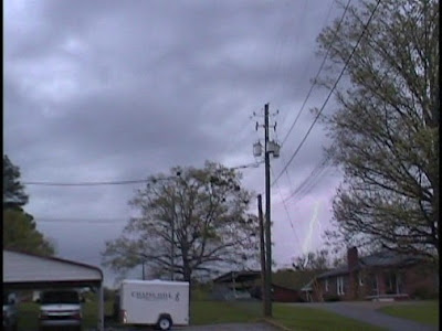
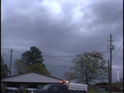
John Brown, Terry Sasser, Sarah Vines, Michelle Henderson, Rick Lipscomb and I witnessed a wall cloud and rain-wrapped EF1 tornado between 3:20 and 3:45 neat Samantha in Tuscaloosa County, Alabama on April 2, 2009. I was very disappointed to learn when I got home that my best footage of the wall cloud was not actually made because my camera was on "pause". You will notice that around the 4:44 point in the video. Fortunately John was streaming video and I am certain that he will post his coverage soon. I hope that Terry and Rick have some good footage. We were listening to the simulcast of James Spann, Chief Meteorologist at ABC 33/40 on 98.1 FM WTXT. James was streaming John's video live on television. The NWS issued a warning at 3:31, I reported a wall cloud at 3:36, and the tornado was on the ground from 3:43 until 3:44. It was on the ground for approximately 3/5 of a mile. It was confirmed as an EF1 by the NWS Birmingham.
Timeline:
Sarah Vines made a very good call while monitoring radar, saying we should head north immediately to view this storm. I agreed and spoke to John and Rick, who were also in agreement. John made a very good decision to leave the church and move just a little farther north, closer to Mitt Larry Road, where we got an excellent view of the wall cloud and rain-wrapped tornado.
3:23 PM Mike Wilhelm: John and I are at Chapel Hill Baptist Church in Northport on Hwy 43
3:23 PM Mike Wilhelm: John will be streaming from here....
3:26 PM Mike Wilhelm: i am at chapel hill baptist church
3:26 PM Mike Wilhelm: lightning popping good now
3:27 Mike Wilhelm: john streaming live looking nnw from the church
3:29 Mike Wilhelm: impressive ctg lightning to the nw
3:31 BMX issues Tornado Warning for Pickens, Tuscaloosa [AL] till 4:00 PM CDT ...* AT 331 PM CDT...NATIONAL WEATHER SERVICE DOPPLER RADAR INDICATED A SEVERE THUNDERSTORM CAPABLE OF PRODUCING A TORNADO 8 MILES WEST OF COKER...OR 6 MILES SOUTHEAST OF GORDO...MOVING NORTHEAST AT 45 MPH.
3:33 Mike Wilhelm - Mobile Laptop - HSV/Decatur: moving north...
3:36 Mike Wilhelm: wall cloud on hwy 43
3:36 abc3340wx_spann: can u get it on camera
3:36 Mike Wilhelm: john just got here, turning towards it now
3:37 Mike Wilhelm: wall cloud nw of mcdonalds on 43
3:38 Mike Wilhelm: storm looks close to 43
3:39 BMX continues Tornado Warning for Tuscaloosa [AL] till 4:00 PM CDT ...AT 339 PM CDT...NATIONAL WEATHER SERVICE DOPPLER RADAR CONTINUED TO INDICATE A TORNADO. THIS TORNADO WAS LOCATED NEAR ECHOLA...OR 11 MILES NORTHWEST OF NORTHPORT...MOVING NORTHEAST AT 45 MPH.
3:41 Mike Wilhelm: rain beginning to get heavy, sheeting
3:41 ki4mqz Berry, Al: john and mike are one mile south of the mitt larry us43 intersection at the clear creek subdivision
3:41 Mike Wilhelm: just south of mcdonald's by 1/2 mile
3:43 Mike Wilhelm: heading east on mill lary, co rd 56
3:46 Mike Wilhelm: heading n on 69
Terry Sasser's Video:
1 comment:
Wayfarer said...
AWESOME!!!! that was a such a great chase Mike. Love the video. Need to do it again soon!
I have been posting about Alabama weather on this blog since April 2006. Here you will find my observations, information provided by the NWS, links to quality weather information from other sources, and historical weather data. Please "follow" me on Twitter and join my "fan" page on Facebook. Twitter and Facebook posts are usually more current/breaking news. I appreciate your visit. Enjoy and come back soon. Thank you!
Follow @bamawx
Bamawx.com - Mike Wilhelm's Alabama Weather Blog on Facebook
The Origin of Northwest Heatwaves and a Toasty Weekend Forecast - * Everyone is talking about the warmth. * Yesterday, high temperatures around Puget ranged from around 60F near the water to 80F in the lower Cascade f...
21 hours ago
Jon Davies Severe Weather Notes
March 25, 2021 deadly tornado outbreak in Alabama and Georgia - One week ago today, a deadly tornado outbreak in Alabama (AL) and Georgia (GA) caused 6 deaths and a number of injuries, making it the deadliest tornado ...
2 weeks ago
The Flight of a South Georgia Storm Chaser
That's why everybody advises me this - That's exactly what I wanted! http://link.denaliatving.com Jennifer
2 years ago
MWN Blog
June 2017 Climate Data for Memphis, TN - June Climate RecapFor the first time in recent memory, Memphis International Airport experienced consecutive months of below average temperatures in May an...
3 years ago
Dr. Jeff Masters' WunderBlog
Meteorology of Saturday's Colombian Flood Disaster That Killed 254 - At least 254 people were killed in the in the city of Mocoa (population 40,000) in southwest Colombia near the border of Ecuador early Saturday, when torre...
4 years ago
The Weather Guy
- Since 2014 the Cookeville Weather Guy has taken a hiatus from posting. At some point in the very near future he will resume. For now you can access his Fac...
4 years ago
Severe Plains
Thanksgiving Cleanup - Mild temperatures and an ambitious brother-in-law meant the opportunity to continue the cleanup of Cedar trees in the rear of the property. With loppers, h...
4 years ago
Tennessee Valley Weather
- I'm very sorry, but this blog has finally kicked the bucket. An informal weather blog will be kept at www.thatweatherblog.blogspot.com, as I have the time,...
6 years ago
EYE OF THE STORM
So... You want to chase a tropical cyclone? - ANYONE that wants to chase a hurricane/typhoon/cyclone should watch this. This is as real as it gets! Thankfully Jim made it through Super Typhoon Haiy...
7 years ago
Iowa WX
Grinnell F3 Tornado of 1978 - This may not be the season for tornadoes and we’ve seen in the past that tornadoes can occur at any time no matter what the calendar says. One such occurre...
7 years ago
WeatherScout
Agilent Indonesia 35670A FFT Dynamic Signal Analyzer - Agilent Indonesia 35670A 2 or 4 channel FFT Dynamic Signal Analyzer, DC-102.4 kHz Description The Agilent 35670A is a versatile FFT analyzer with built in ...
7 years ago
Prairiestorm Media Blog
sky drama - Haven't released anything officially, but for the sake of updating... if you're coming here looking for recent posts, STOP. Sky Drama is coming.
8 years ago
Storm Chasing Mikey
Hurricane Sandy - Hurricane Sandy Intensifies Over Jamaica Hurricane Sandy did not disappoint and has indeed become the Historic Storm we started watching on long range fore...
8 years ago
SOUTHERN WEATHER BRIGADE
Virginia Lightning - On Wednesday May 23rd, we had a very isolated cell with a strong hail core move up from North Carolina into Southeastern Virginia around 10:30pm est. I lo...
8 years ago
Justyn Jackson's Weather Blog
Dual-Pol Applications - Dual-pol installations are now being pushed in full force across the country. As of this post, eight radars are equipped with dual-pol, including the proto...
9 years ago
Southwest Georgia Stormtrack
A reminder......... - I work hard and go to considerable expense to capture my work. So please consider this before stealing any of my work. If you do, I will find you and the ...
9 years ago
High Plains Drifter
test image - this is only a test
9 years ago
Alaska Weather Blog
Tuesday March 8, 2011 - Things are really warming up right now! I know that sounds funny, especially since temps are still below freezing, however with the additional daylight (10...
10 years ago
Dan's Wild Wild Weather Journal
Did The Press Miss the Boat on The Black Hole Story?? - This page will soon no longer be updated- go to the new home at THE AGU BLOGOSPHERE You likely heard about it a few days ago. NASA announced the detection ...
10 years ago
Iowa Chaser
NEW BLOG -- Update Link - The Iowa Chaser blog is now the Severe Plains blog! All of the previous posts have been moved, and additional posts since December have been added to the n...
11 years ago
The Long Distance Chase Team...
Best of Hurricane Video!!! - Sorry it took me so long, but I finally put up the Best of Hurricane Video on youtube... It's from Hurricanes Ike, Rita, and Katrina... Honestly words can...
11 years ago
Nikki-Dee’s
*Your Baghdad Weather Glance* -
11 years ago
Tommy Self's North Alabama Weather Blog
Vortex 2 - Well it has been kinda dull weather wise around here the last few days so I turn my attention to the plains and the great tornado hunt.Looks like they ...
11 years ago
WSFA 12 Weather Blog
-
NSSTC Collaborative Weather Blog
-
Green Screen Weather
-
Severe Storm & Hurricane Video & Pictures, Florida Weather, Stock Footage, Storm Chaser Jeff Gammons - Weatherzine.Net
1 comment:
AWESOME!!!! that was a such a great chase Mike. Love the video. Need to do it again soon!
Post a Comment