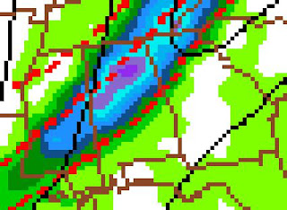
This was Wednesday's (4/2) 18z (1 p.m. CT) GFS output, valid for 1 a.m. Saturday, showing a band of very heavy rain moving through North and Central Alabama. It looks particularly heavy for my area, which is showing the most convection. I will be in Starkville, though, at (of all places) the MSU Southeast Severe Weather Symposium.
This is Wednesday night/Thursday morning's (4/2-3) 0z (7 p.m. CT) GFS output, valid for 1 a.m. Saturday. The convection is not as intense and the line comes in just a little later.

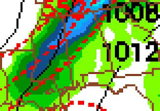
This is Thursday's (4/3) 6z (1 a.m. CT) GFS output, valid for 1 a.m. Saturday.

This is Thursday's (4/3) 12z (7 a.m. CT) GFS output, valid for 1 a.m. Saturday. Each run seems to have gradually reduced the rainfall output.
----------------------------------------------
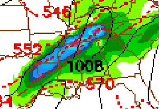
The time of greatest concern for tornadic weather, might be the evening hours beginning at 3 p.m. This is when isolated supercells would be forming, if the conditions are favorable. The above image is from today's 12z GFS guidance, effective at 7 p.m. Friday.


No comments:
Post a Comment