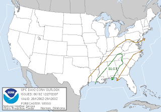
The Storm Prediction Center has included most of the State of Alabama in a "slight risk" area tomorrow. Do not let the term "slight risk" confuse you. Usually severe weather will occur in your area when a slight risk is issued. This risk area very well may be upgraded to moderate tomorrow morning.
This thing does look nasty for tomorrow. The shear values may be really high. As always this time of year I question the amount of instability. Apparently with the SPC predicting convection way to our north, warm air advection will be stronger than usual, contributing to greater instability. I would not be a bit surprised to see a moderate risk issued by tomorrow morning.
Here is a portion of the SPC Convective Outlook, issued this morning:
LOWER MS VALLEY INTO TN VALLEY...PRIMARILY ELEVATED THUNDERSTORMS WILL BE ONGOING AT THE START OF THE PERIOD OVER PARTS OF LA AND MS IN ASSOCIATION WITH STRONG WARM ADVECTION AS A 50-60 KT SSWLY LOW LEVEL JET MOVES ACROSS THE LOWER MS VALLEY. MOISTURE IS EXPECTED TO CONTINUE INCREASING NWD DURING THE MORNING WITHIN THE EXPANDING WARM SECTOR...CONTRIBUTING TO AIR MASS DESTABILIZATION WITH MUCAPE OF 500-1000 J/KG FORECAST BY 15-18Z. FORECAST SOUNDINGS SUGGEST SURFACE-BASED CONVECTION WILL BECOME MORE LIKELY BY MID MORNING WITH AN INCREASING THREAT FOR A FEW SEVERE STORMS TO DEVELOP. VERY STRONG DEEP LAYER SHEAR /50 KT OR GREATER IN THE LOWEST 6 KM/ WILL ENHANCE STORM ORGANIZATION ANDINTENSITY AND PROVIDE A FAVORABLE KINEMATIC ENVIRONMENT SUPPORTIVE OF SUPERCELLS. IN ADDITION...VERY STRONG LOW LEVEL SHEAR AND SRH SUGGEST A POSSIBILITY FOR ISOLATED TORNADOES...MAINLY OVER PARTS OF SERN LA...SRN/ERN MS...NRN/WRN AL...AND NWRN GA THROUGH THE AFTERNOON HOURS.
Morning discussion exerpt from Jackson, MS (These guys do a good job):
FOR FRIDAY A WARM FRONT WILL PUSH ACROSS THE EASTERN HALF OF THE REGION AS A COLD FRONT MOVES ACROSS THE EAST PORTION OF THE REGION DURING THE AFTERNOON. THE SURFACE LOW WILL QUICKLY PUSH NORTHEAST ALONG THE FRONT DURING FRIDAY MORNING. SHOWERS AND SCATTERED EMBEDDED THUNDERSTORMS WILL MOVE ACROSS THE REGION. THE THUNDERSTORMS WILL BE GENERALLY ALONG AND AHEAD OF THE FRONT. IF THE GFS IS CORRECT WITH ITS LOW LEVEL MOISTURE RETURN...THEN SOME OF THE STORMS WITH THE FORCING AND INSTABILITY WILL BE STRONG TO SEVERE SOUTHEAST OF THE NATCHEZ TRACE WITH THE BEST CHANCE ALONG AND SOUTHEAST OF THE INTERSTATE 59 CORRIDOR. HOWEVER...THE 00Z ECMWF/UKMET ARE NOT AS ROBUST WITH RETURN FLOW AND THIS LENDS TO A BIT OF DOUBT IN THE GFS SOLUTION. LOOKING AT THE FORECASTED INSTABILITY BASED ON THE GFS...MID LEVEL LAPSE RATES ~6-7C...CAPES 300 TO 1600 J/KG ACROSS EAST AND SOUTHEAST MISSISSIPPI (BEST CAPES ALONG AND SOUTHEAST OF 59 CORRIDOR...LI -2TO -5... SHOWALTER INDEX...-1 TO -2...DEWPOINTS LOWER 60S (MAVGUIDANCE)...0-1 KM HELICITY >450...0-1 KM SHEAR AROUND 35 KNOTS. WITH THIS IN MIND WE WILL BE LOOKING AT ISOLATED STRONG TO SEVERE STORMS WITH DAMAGING WINDS...HAIL...AND ISOLATED TORNADOES...WHICH WILL BE OF GREATEST CONCERN ALONG THE INTERSTATE 59 CORRIDOR. FORECAST SOUNDINGS SHOW THAT CONVECTION MAY BECOME SURFACE-BASED IN THE RISK AREA. SUPERCELLS AHEAD OF THE COLD FRONT WILL NOT BE OUT OF THE QUESTION.


6 comments:
Even something severe would drop some precipitation... so mayeb some good along with the bad. The QPF maps show some good amounts around your neck of the woods, and with PWATS around 1.25"... I'm hoping your rain is substantial.
The Christmas weekend snow at my house was 9" and yesterday a Clipper stalled out over the region and gave me another 5". This puts my total snow depth at 18.5". I'm allowing the final core sample to melt over the heating vent, so I don't yet have water equivalent.
Thanks Nathan. If that 1.25" falls in Birmingham, they will avoid having the driest year on record. They need 1.07″ to avoid being the driest ever and that seems much more likely now.
It looks like we will have the second driest year, unless we can somehow squeeze out 6.07″ during the next five days. I just don’t see that happening.
Your snow depth has been high all winter. You won't be seeing much of the ground for awhile!
Hey mike...you're all over this possible severe weather situation...good job watching!!
ROLL TIDE!
Thanks Mike and Roll Tide! I just don't know if it will be warm enough for severe in North Alabama....it may be in Central/South...but we'll see...
Hey Mike!!!
Just sitting here waiting on the new day 1 outlook. It will be interesting to see if the instability can get up into the Tennessee Valley tomorrow. The wind shear is "crazy go nuts"...& thus it won't take much to get things going. Might even see some rotating showers without thunder & lightning! Certainly looks like it will be active for South Alabama for sure.
If the sun were to come out tomorrow morning into the afternoon all bets are off!
James P.
Hi James, Looks like the SPC has moved it south.
Post a Comment