Last night I posted a forecast map for the potential snow in Alabama for Thursday night and Friday. I intentionally placed the area of higher accumulations further north than the models showed. I believed that the GFS and NAM models' initial bias were to shunt the low pressure too far to the south. Lo and behold, this morning's 12z runs of the NAM and the GFS are trending northward. That means better news for snow lovers who live anywhere between Birmingham and the Florida state line. As the potential event gets closer, we should get a better handle on the areas most likely to be affected. I would not be surprised to see the NWS offices in Birmingham and Mobile issue Winter Storm Watchs before today is over.


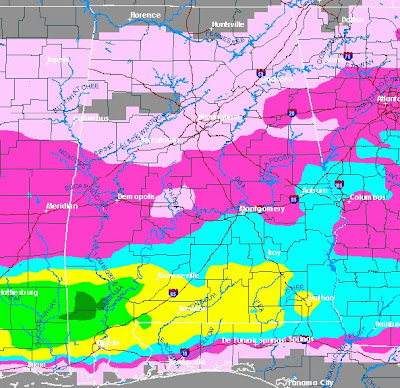
Above is a composite map I pasted together of the 12z NAM output for snowfall accumulations over the next 84 hours. Amazingly, the
NAM is predicting 3-6 inches over south Alabama counties such as Washington, Mobile, Clarke, Baldwin, Monroe, Escambia, Conecuh, Butler, Crenshaw, Covington, Pike, Coffee, Geneva, Dale, Henry, and Houston.
Amazing possibilities with this system!
The 12z NAM is showing at least some accumulation in every county of Alabama! Stay tuned!
...


No comments:
Post a Comment