Friday, December 15, 2017

December 16, 2000 Tuscaloosa F4 Tornado

Photo by Michael E. Palmer, Tuscaloosa News
Michael Harris carries an unconscious Whitney Crowder, 6, through the Bear Creek Trailer Park, 12/16/2000
Saturday morning December 16, 2000 was a pleasant and warmer than average mid-December morning in Tuscaloosa, Alabama. But to those paying attention to the weather, there was legitimate concern that conditions would not stay so pleasant. At 10 a.m., a Tornado Watch was issued for the area. And at 12:40 p.m., the National Weather Service in Birmingham issued a tornado warning for Tuscaloosa County. Fourteen minutes later, at 12:54 p.m., a tornado touched down in southwestern Tuscaloosa County, west of the Black Warrior River. It was on the ground for 18 miles and was responsible for 11 fatalities and 144 injuries, according to the Tuscaloosa County EMA. 

Birmingham Nexrad, 12/16/17 at 12:57 p.m., 3 minutes after tornado touched down.

NWS Birmingham path map of 12/16/2000 Tuscaloosa tornado
The photo at the top of this post, by Michael Palmer of the Tuscaloosa News, circulated across the world via the Associated Press.  The girl in the picture, Whitney Crowder, survived the tornado but she lost her father and baby brother to the tornado.  Katherine Lee, of the Tuscaloosa News wrote about the Crowders' story in a touching article at this link.  Whitney told the News that her memories of that day begin when she woke up in Children's Hospital and saw friends and family at her bedside. “My first-grade teacher was there. I remember walking around the hospital and seeing my sister Abby.“ Otherwise, she relies on videos, photos and other people’s versions of events.  More on the Crowders' story can be seen in the 2014 WVUA report which is embedded below.


ABC 33/40 Chief Meteorologist James Spann and his team, which included meteorologists Mark Prater and John Oldshue, did an excellent job providing coverage of this storm, and were awarded an Emmy. ABC 33/40 captured the tornado on a tower camera as it moved through the southern part of Tuscaloosa. James wrote later, "Our StormChaser van was heavily damaged in the storm; John Oldshue and his photographer had to rush in to a Hampton Inn to protect themselves as the tornado passed right over their location. The manager of the motel had all of the guests lined up in a hallway on the lowest floor, and nobody was injured there." Below is video of ABC 33/40 coverage.


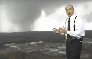
The screen capture below is from WVUA Tuscaloosa coverage of the tornado.


This was the strongest tornado in Tuscaloosa in at least 50 years (since 1950) and it was the strongest December tornado in Alabama since at least 1950. It was the deadliest tornado in Alabama in 2000 and tied with a tornado in Georgia as the deadliest in the nation that year.  According to the National Weather Service Birmingham, "The tornado was spawned by a supercell thunderstorm that originated in Mississippi. This thunderstorm was responsible for additional tornado damage in St. Clair and Etowah counties...Tuscaloosa EMA reported 11 fatalities with this tornado along with 144 injuries. Nine of the fatalities occurred in mobile homes, one in a vehicle, and one in a commercial building converted to residential use. Six of those killed were females and five were males. Ages ranged from 16 months to 83 years old. The tornado was on the ground for a total of 18 miles, all within Tuscaloosa county. The tornado path was estimated to be 750 yards wide at it's maximum intensity." Complete storm survey information from the NWS Birmingham, including photos, can be found at this link. 

Interestingly, researchers from Texas Tech University's Wind Science and Engineering Center believed that the damage was more consistent with actual wind speeds in the F2 range because the Fujita Scale did not take into account the building types nor quality of construction.  This helped lead to the "Enhanced Fujita Scale' or EF scale, which became operational in the United States in 2007. 

Three other tornadoes occurred in Alabama on December 16, 2000.  One of those was responsible for the death of a woman in Geneva County who was thrown 75 yards from her mobile home.  A total of 24 tornadoes occurred that day across the Southeastern United States.

Mike Wilhelm
@Bamawx on Twitter
Bamawx Facebook.

---


Friday, November 10, 2017

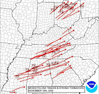
Veterans Day Tornado Outbreak - 11/10/2002


Eighty three tornadoes were confirmed by National Weather Service offices in 17 states, mostly east of the Mississippi River between November 9 and November 11, 2002.  Most of the tornadoes occurred on the 10th in the Southeast and Ohio Valley regions.  Twelve of the tornadoes were responsible for 36 deaths.  Thirteen deaths occurred in Tennessee and 12 in Alabama. The most intense tornado was the F4 in Van Wert, Ohio which was responsible for four fatalities.  This ranks as the third largest November tornado outbreak.

Alabama Tornadoes:


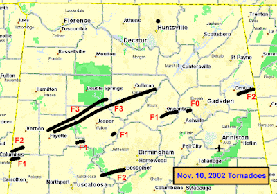
Map of 11/10/02 Tornadoes in Alabama via NWS Birmingham

8:40 p.m. Infrared Satellite Image 11/10/02 during Saragossa F3, NWS Bmx

The National Weather Service Birmingham has a page with storm surveys of 10 tornadoes in Alabama.  The most devastating tornadoes in Alabama were the Carbon Hill (F3) and Saragossa (F3) tornadoes.

Carbon Hill F3 Tornado
The Carbon Hill tornado was travelled 44.3 miles with a width of 1175 yards. According to the NWS Birmingham, "four deaths were reported with this tornado, three in the Rose Hill community area of Walker County and one near Arley in Winston County, with approximately 38 injuries associated with this tornado, 3 in Fayette County, 20 in Walker County, and 15 in Winston County."

The video below contains coverage from meteorologists in the Huntsville television market, even though the tornado was mostly south of the Huntsville market. All three stations, WHNT, WAAY, and WAFF were all following it closely.  As of this time the Weather Service Office in Huntsville was not issuing warnings. The NWS Birmingham still had warning responsibility for all of North Alabama.


The video below is coverage from an ABC 33/40 special on severe weather in 2005. In this video, the Carbon Hill tornado and Saragossa tornado from the "Veterans Day Outbreak" in Alabama are discussed. Reporters include James Spann, Pam Huff, Valorie Carter, Brian Peters, Ike Pigott, John Oldshue, Linda Mays, and Chris Tatum.


Saragossa F3 Tornado

According to the NWS Birmingham: "The Saragossa Tornado was the fourth tornado to occur in Alabama and the longest track of the severe weather episode. It began in Fayette County, just east of the Sipsey River about 6 miles north-northeast of the city of Fayette at 8:15 pm...The tornado crossed into Walker County at 8:34 pm...The tornado appeared to be at its most intense during the travel from US 78/SR 118 interchange across Saragossa and the areas near SR 5 and SR 195. Seven deaths occurred in this 10 mile stretch of the tornado track, along with an estimated 40 injuries."

This is coverage of the most deadly and longest track tornado in Alabama during the Veterans Day Outbreak, 11/10/2002. James Spann, Mark Prater, John Oldshue and J.B. Elliott covered this tornado which moved through Fayette, Walker, Winston and Cullman counties. This video included coverage from 8:30-9:09 p.m.


Finally, meteorologists Ben Smith and Dr. Tim Coleman of Channel 42 in Birmingham describe the F2 tornado that moved through Tuscaloosa and Jefferson counties.

From the NWS Birmingham: "The Abernant Tornado touched down in a wooded area west of County Road 99 around 10:22 pm. The tornado traveled east-northeast, damaging structures on Ridge Road before crossing into Jefferson County. The tornado entered Jefferson County at 10:29 pm, and damaged structures in the Johns and Sumter areas before damaging a manufacturing facility just southwest of VisionLand Theme Park. The tornado crossed Interstate 65 and US Highway 11 where additional houses and businesses were affected. The tornado ended at this point at 10:43 pm. This F2 tornado had a path length of 15.2 miles, 2.9 miles in Tuscaloosa County and 12.3 miles in Jefferson County. The path width was about 450 yards. Three injuries were reported in Tuscaloosa County.


Tuesday, November 07, 2017

Storm Chasing 11/8/89 in Tuscaloosa and Hale Counties, Alabama

George H.W. Bush was President of the United States. Power ballads such as "When I See You Smile" by Bad English were topping the charts. Jerome Walton of the Chicago Cubs won the NL Rookie of the Year Award. And, not surprisingly, there was severe weather in Alabama.

Severe thunderstorm approaching Highway 69 in Hale County, Alabama, 11/8/89
The morning of Wednesday November 8, 1989 an F1 tornado struck the northeast side of Dothan in Houston County, Alabama. During the afternoon of November 8, severe reports were confined to a few wind damage reports in West Alabama, but it happened to be a day I remember for a few reasons. My first "storm chasing" experiences were in the 1980s and most of them are not documented. This is not the first, but one of the first I was able to document on video. 


From NOAA Storm Data, November 1989

In these videos you will hear audio of the Birmingham NWS NOAA Weather Radio (with real human voices) and audio of James Spann, Scott Richards, and Janet Hall who were broadcasting the evening news on WBRC 6.  I was listening to them on 87.7 FM.  Channel 6 was the only station in the Birmingham market which had audio fall within the FM radio band. This disappeared when Channel 6 went digital in June 2009. 

Here are the videos:


Thanks for reading and watching!

Mike

Follow me:

Twitter

Facebook

Instagram

Thursday, July 27, 2017

Nashville Tornado - 7/26/10 - "Being Chased"

On July 26, 2010 I had the opportunity to attend my seventh (7th - you heard right) Paul McCartney concert. This one was at Bridgestone Arena in Nashville, Tennessee. With me were my son Matthew and my dear friends from school days Rob and Johnny. The concert was amazing. You may be asking, "What does this have to do with weather?" Good question!  It turned out that while the four of us, along with thousands of other fans were waiting for the doors to open to the arena, a severe thunderstorm with intense lightning and what was later to be confirmed by the National Weather Service Nashville to be an EF1 tornado was in the area. Instead of chasing storms, we were being chased!


The image above shows what the sky looked like from Bridgestone arena. While standing in a sea of people waiting to get in, we could hear the thunder getting louder and closer. In what I considered a very questionable response, the arena refused to open the doors early, leaving fans exposed to the approaching severe weather.


Around this time, an EF1 tornado was in progress about 7 miles to our north. It was on the ground for about 1/2 mile and had winds in the 105-110 mile per hour range. According to the NWS Nashville:

"Areas along Westchester Drive experienced much more significant damage. Approximately 12 brick homes suffered heavy roof damage, including one which had a large section of the roof removed. Two buildings were impaled by two by fours, and a couple of dozen windows were blown out. The damage pattern in this area was characterized by convergence and obvious rotation consistent with a tornado. Damage that occurred was also consistent with the highest end of the EF-1 range, 105 to 110 mph."
 
I will never forget that the instant we walked in the doorway to the arena, lightning struck right outside, perhaps hitting one of the tall buildings in the area. To my knowledge, everyone got in safely but it was a close call. I plan on going back through my files to see if I happen to have any video of the weather outside prior to the concert. The concert itself was awesome, by the way!


Here are some more photos! And below is my video of Paul performing "Something"!


Friday, May 19, 2017

Northeast Alabama Tornadoes May 19, 1973


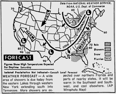
Source: Florence Times-Daily, May 19, 1973

On Saturday May 19, 1973, the number one song in the U.S. was “You are the Sunshine of My Life” by Stevie Wonder.  If you went to the movies you probably saw “Paper Moon” starring Ryan O’Neal. If you were watching television “All in the Family”, “M*A*S*H”, Mary Tyler Moore, Bob Newhart, and “Emergency” were popular on Saturday nights.  For residents of Fort Payne, Alabama, television was the furthest thing from their minds as they were recovering from an F4 tornado that struck between 6:45 and 7:00 p.m.

May 1973 was an active month for tornadoes in Alabama and the 19th was certainly a red-letter day. Three tornadoes were confirmed to have occurred during the afternoon and evening hours on May 19, 1973: An F2 in Madison County near Hazel Green, an F2 in Jackson and Dekalb counties which affected South Scottsboro, Section, and Powell, and an F4 which affected Fort Payne and Lookout Mountain in Dekalb County.

The Madison County tornado was on the ground for two miles in Hazel Green and it caused 10 injuries, destroyed at least five buildings and damaged 30 others around 2:40 in the afternoon.

The second tornado, also an F2, touched down at 4:15 p.m. near Scottsboro and Section.  This tornado was on the ground 23 ½ miles through Jackson and Dekalb counties. Nine people were injured in this storm.  At least 12 trailers and 15 buildings were destroyed.  80 other buildings were damaged. This was the longest track tornado of the day, but not the most intense.


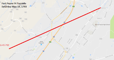
The third and most intense tornado of the day, an F4, touched down at 6:45 p.m. in Fort Payne.  On the ground for 5.4 miles, this tornado caused 19 injuries. At least 37 buildings were destroyed just north of downtown Fort Payne and 117 buildings were damaged. 150 people were attending the “Little Miss Maid of Cotton” contest at a school gymnasium.  Attendees took cover against the walls of the gym just before the tornado struck. Despite damage to the gymnasium, there were no injuries at the school.

5/20/73 Florence Times-Daily

Mike Benefield commented in Stormtrack.org that a two-story, 16 unit apartment complex was moved about 150 feet into the middle of Main Street. He also said that debris from Fort Payne businesses was found in Rome, Georgia. 

The best news of the day was the fact that no one was killed as a result of these tornadoes. 

Sources:

NWS Birmingham Alabama Tornado Database: https://www.weather.gov/bmx/tornadodb_1973

Florence Times-Daily

Alabamawx.com

Friday, May 05, 2017

Killer Tornadoes of May 5, 1933

Two devastating tornadoes were responsible for 25 deaths and 227 injuries in Central Alabama in the predawn hours of May 5, 1933. 

The first was an F3 tornado which touched down at 12:20 a.m. and moved through Choctaw, Sumter, and Marengo counties, killing four and injuring 27 people along its 35 mile long path. Three of the fatalities occurred at Demopolis in Marengo County where 50 homes were destroyed. 

Unidentified Survivors of Helena Tornado, Photo: Army Air Corps

The second tornado touched down around 2:30 a.m. and moved through Bibb and Shelby counties along a 35 mile long path.  This tornado had damage consistent with an F4 rating and was responsible for 21 deaths and 200 injuries.  Hardest hit was the Shelby County town of Helena. There 14 were killed and 150 were injured.  Five were killed in Brent in Bibb County and one was killed in the Colemont community. 

May 1933, Helena, Alabama Tornado Damage Path, Army Air Corps
The photos above were taken by a pilot with the U.S. Army Air Corps and can be seen in the Helena Museum.  Most of the town of Helena was directly impacted by the tornado and the Helena Depot was one of the few buildings that survived.

The Shelby County Reporter had this to say about the disaster in Helena in its September 9, 1972 edition:

"Roaring out of the southwest at a little past three o'clock in the morning this deadly tornado killed 20 people and caused a vast amount of property damage and human misery. The tornado's having come at night made the visitation more terrifying. Most of the people were asleep in their beds or had been awakened just as their homes were being swept away. Many found themselves buried under the ruins of their homes and had to wait for relief to come. Torrents of rain poured down following the storm. Ambulances from Birmingham responded as promptly as possible, but fallen trees and debris hampered the work of relief."

Laura Brookhart wrote a very good artcle on the tornado in the September 10, 2012 edition of the Shelby County Reporter.  Here is an excerpt:

I was crouching in a second story middle room with my brother and sister. My brother told me not to look up, but I did,” Paty said. That was her last memory until she awoke in a field, holding her brother’s hand. She estimates they were some 25 feet from where their home once stood. “We were all in our pajamas. My sister escaped without a scratch. We went for help.” Though she did not realize it, Paty had a gash in her cheek that ‘four fingers could be inserted into’ and her hair had been torn out. “Our home was leveled. The only things we were able to salvage were one chair with no legs, a table and a radio.”
If you have photos, memories, or other information to share about this disaster, please email those to me at .  I can also be contacted via Twitter @Bamawx or on my Facebook Bamawx page.
Sources:
NWS Birmingham Alabama Tornado Database
Shelby County Reporter
AP Article
Helena Museum


Wednesday, May 03, 2017

May 3, 1984 Tornado Outbreak in Alabama

On this date in 1984, 17 tornadoes occurred in Alabama. The most significant tornado occurred in Montgomery, where five people were killed and 37 injured in an F3 tornado which touched down just before rush hour on the Northern Bypass at 7:00 a.m.  Four of the fatalities were in automobiles and one in a mobile home.  According to the Alabama Tornado database from the NWS Birmingham:

"Damage was extensive along the entire path of the tornado. At least 20 homes were destroyed, 36 homes sustained major damage, 157 homes had minor damage, 9 mobile homes were destroyed, 8 businesses were destroyed, and numerous vehicles were destroyed."

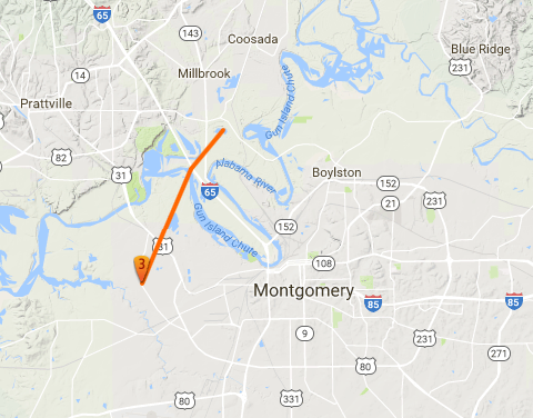
The map below from
TornadoHistoryProject.com shows the path of the Montgomery tornado.  

TornadoHistoryProject.com
This was the first big weather event for longtime WSFA Chief Meteorologist Rich Thomas. He later described the event for PrimeMontgomery.com:

"More tornadoes struck that afternoon, with a funnel cloud even passing over the station. The power went out but the broadcast continued with an emergency generator, one camera and a light.  'We went wall to wall (continuous coverage),' he said. 'I was 28 years old, and it was a trial by fire!'  The station general manager was so impressed with his coverage that day he gave him $100."
 
According to the Monthly Weather Review from May 1984:
 

Four of the deaths and several of the 37 injuries occurred when the tornado damaged or destroyed about 25 vehicles that were travelling on a (northern) bypass. Some of the victims were thrown from their cars which were carried or rolled 92 m (1oo yards) from the road.  The fifth fatality was the occupant of a mobile home.” 

According to a UPI article:


"Alabama Gov. George Wallace declared a state of emergency and asked President Reagan to declare the state a disaster area. A trucker whose 18-wheeler was blown away in the funnel cloud that set down on the four-lane Northern Bypass highway in Montgomery said the twister tore out the seat of his pants. 'I don't know whether I was blown away from the truck or whether the truck was blown away from me. It was a mess,' said Amos Garmon. 'The seat of my britches was out. It just about tore my clothes off." Police officers used long sticks probed the swampy area next to the road, trying to determine if bodies were thrown into the morass, but by late Thursday night none had been found. Spokesmen said 17 people were taken to Baptist Medical Center in Montgomery and 13 to Jackson Hospital. 'The injuries range from lacerations and bumps and bruises to very serious injuries,' said Baptist spokesman Gene Hannah. 'We've got three patients in surgery. We've got one patient who had a coronary.' Ronald Jackson, 21, said he was driving down Northern Bypass when 'the wind picked up and things started blowing around. Juts before we pulled over I saw it coming from the southwest. I was scared as hell. Jackson, who suffered contusions and lacerations, said his car was 'turned over in the ditch and picked up and dropped again.' 'I was screaming 'Make it stop'' he said. He said he saw cars 'in trees and in ditches' after the tornado passed." 


No fatalities were reported in any of the other 16 tornadoes which occurred across Alabama that day. 
TornadoHistoryProject.com
 
Following is a list of the other tornadoes which were confirmed in the morning and early afternoon of May 3, 1984 according to the Birmingham National Weather Service:

12:30 a.m. SW Limestone F1 A tornado struck near Clements High School and moved NE.  One barn was destroyed, a home unroofed, and at least 100 trees were downed.


7:10 a.m. Macon F1 S Milstead
Two homes were damaged and trees were knocked down.


8:10 a.m. Henry F1 Lake Eufaula
Several mobile homes were damaged and many trees were blown down.
10:48 a.m. Sumter F0 6 S York
Tornado briefly touched down and uprooted some trees.
11:30 a.m. Shelby F1 Vincent
Most of the damage was confined to downed trees.
11:35 a.m. Shelby-Talladega F2 W Childersburg-Winterboro
Several structures were damaged or destroyed along the path. Numerous trees were blown down.


From NOAA "Storm Data" Publication May 1984
 
11:40 a.m. Dallas F2 Selma
A 300 foot TV tower was leveled and it caused extensive damage to the building below. One manufacturing plant was heavily damaged.


From NOAA "Storm Data" Publication May 1984
 
11:49 a.m. Dale F0 SE Daleville
A small tornado briefly touched down in an open field with little or no damage.


11:56 a.m. Dale F2 Midland City
A high school campus was heavily damaged and a few buildings were actually destroyed. Several other buildings and homes suffered damage along the path

From NOAA "Storm Data" Publication May 1984
12:15 p.m. Clay-Randolph F2 0/2 Union-Folsom
Several mobile homes or outbuildings were damaged or destroyed along the path.


From NOAA "Storm Data" Publication May 1984
12:18 p.m. Cleburne F2 Taylor-Beason Mill-Arbacoochee
6 homes were damaged, 2 mobile homes were destroyed, and numerous trees were blown down

12:22 p.m. Cleburne F1 Heflin-SW Edwardsville
Some homes sustained roof damage, one mobile home was destroyed, and many trees were blown down.
12:35 Randolph F1 Morrisons Crossroads-Newell-Pine Hill
One barn was destroyed and one home damaged at Morrisons Crossroads. Outbuildings were damaged at Newell. Several trees downed in the Pine Hill Community.
12:40 p.m. Cleburne F2 S Hightower-SE Ranburne
3 barns and 2 chicken houses were destroyed. 10 other homes sustained roof damage and numerous trees were downed.


 1:00 p.m. Macon F2 Pleasant Hill-Little Texas
A 30K gallon tank was pulled off its foundation and moved 10 ft. 3 buildings were destroyed, 4 homes were damaged, and numerous trees were downed.


1:30 p.m. Lee F2 0/1 Smiths
A grocery store, a restaurant, a hardware store, a several mobile homes were destroyed. One person was injured in a mobile home. Hundreds of trees were downed.


Numerous other severe reports can be found in NOAA NESDIS Storm Data Publication for May 1984.

Tuesday, May 02, 2017

Alabama Hail Storm May 2, 2003

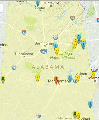
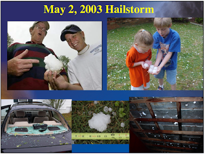
On this date in 2003 some of the largest hail ever recorded in Alabama fell, with numerous reports of hail as large as baseballs and softballs. Below is a list from the NOAA Storm Data publication for 2003. Significant damage to roofs and automobiles was reported. Boundary interactions led to storm initiation in a high CAPE (very unstable) environment.  Despite many rotation signatures on radar, no tornadoes were confirmed in this event. CAPE values were as high as 3500-4000 j/k.   

SPC Storm Reports 5/2/2003


Etowah: 1:53-2:44 p.m. Baseball 2.75"
"Penny to baseball size hail fell along the eastern Etowah County line. The hail fell from near Keener to near Ball Play. A few trees were also blown down near Ball Play. The hail may have been larger in rural areas because of larger reports in adjacent counties."

Cherokee County: 2:29-3:22 p.m. Softball 4.5"
"Hail up to the size of softballs fell across western and southern Cherokee County. Many locations reported the hail was covering the ground. Most of the hail fell across rural areas."

Calhoun County: 2:54-3:25 p.m. Golf ball to Softball 4.5"
"Very large hail fell across extreme northern Calhoun County. A majority of the hail was golf ball size and covered the ground in a few locations. A few reports were received that a couple of the pieces of hail were softball size. Most of the hail was thrown out of a storm located farther north in Cherokee County and little rain was observed with this storm."

Marengo 3:35-3:54 p.m. Tennis ball 2"
"Hail up to 2 inches in diameter was reported in extreme northeast Marengo County near Faunsdale."

Hale County 3:45-4:26 p.m. Baseball 2.75"
"A large swath of hail moved through the heart of Hale County. Hail up to the size of baseballs was reported along the path. Several automobiles received windshield damage from the large hail. Several trees and power lines were also blown down during this storm near Greensboro. This was the third large hail producing storm to affect Hale County during the afternoon hours."

Jefferson County 4:47-6:04 p.m. Baseball 2.75"
"A supercell thunderstorm moved across western Jefferson County and produced a large swath of hail. The largest hail reported was baseball size but the hail may have been larger in surrounding rural areas. Large hail was reported in Sayre, West Jefferson, Hoover, Hueytown, Bessemer, Birmingham and Palmerdale. A few locations observed hail covering the ground. Numerous reports of funnel clouds were also received."

Shelby County 5:40-7:00 p.m. Softball 4.5"
"Several severe thunderstorms moved through Shelby County and generally affected the western part of the county. All of the storms produced dime to golf ball size hail. The largest hail size reported was softball and occurred near Maylene. Some locations that reported hail were Alabaster, Hoover, Helena, Maylene, Indian Springs, Calera and Montevallo. Several locations observed hail covering the ground. A few trees were also blown down."
 
The Shelby County Reporter wrote about the hailstorm the following day and said, in part:
 
"National Weather Service Meteorologist Brian Peters said reports of hail measuring four inches in diameter, among the largest ever reported in Shelby County, came from Maylene. Additional reports of hail ranging in size from one to three inches in diameter was reported from Helena, Pelham and Alabaster. We had a lot of reports of golf-ball-size hail and judging from the reports of car damage there’s no reason not to believe that, Peters said. We also had a number of baseball-size hail reports. Hail is formed when a cold atmosphere prevents larger droplets of rain from falling out of thunderstorm clouds allowing them to freeze, Peters said."

Shelby County was under the following tornado warning at the time this storm occurred:

BULLETIN - EAS ACTIVATION REQUESTED
TORNADO WARNING
NATIONAL WEATHER SERVICE BIRMINGHAM AL
624 PM CDT FRI MAY 2 2003

THE NATIONAL WEATHER SERVICE IN BIRMINGHAM HAS ISSUED A

* TORNADO WARNING FOR...
SHELBY COUNTY IN ALABAMA

* UNTIL 730 PM CDT

* AT 624 PM CDT...NATIONAL WEATHER SERVICE DOPPLER RADAR INDICATED A TORNADO 13 MILES NORTHWEST OF HELENA...MOVING SOUTHEAST AT 25 MPH.

* LOCATIONS NEAR THE PATH OF THIS TORNADO INCLUDE...ALABASTER... CALERA...CHELSEA...COLUMBIANA... HELENA...INVERNESS...LAKE PURDY...MONTEVALLO...OAK MOUNTAIN STATE PARK...PELHAM AND
WILSONVILLE. ANOTHER SEVERE THUNDERSTORM WAS NEAR PELHAM AND
INVERNESS MOVING EAST AROUND 30 MPH. VERY LARGE HAIL CAN BE
EXPECTED WITH EITHER OF THESE STORMS.

THIS IS A DANGEROUS STORM. IF YOU ARE IN ITS PATH...SEEK SHELTER NOW. STAY AWAY FROM WINDOWS.
 

NWS Huntsville / Bamaweather.com

Other areas receiving baseball sized hail in Alabama:

Lawrence County - Mount Hope
Colbert County - Colbert Heights
Franklin County - Russellville
Lauderdale - Petersville, Central Heights, Cloverdale

2.5" Hail (tennis ball) fell in:

Cullman County: Baileyton
Washington County: Chatom

Images from the NWS Huntsville:

NWS Huntsville

NWS Huntsville

Numerous other areas of the state received hail that met severe criteria (which was 3/4" at that time).  Those areas are too numerous to mention here.  There were also several severe wind reports. 

Sources:

NOAA Storm Data May 2003
NOAA Storm Events Database
Shelby County Reporter
Storm Prediction Center
NWS Birmingham
NWS Huntsville - Slide presentation by Matt Zika


Monday, May 01, 2017

May Day Tornadoes in Alabama, May 1, 1953


Chicago Tribune, 5/2/1953

At least four tornadoes occurred in Alabama on this date in 1953, including two that are thought to have been of F4 intensity.  Nine people were killed and 17 were injured in Alabama that day.

Tornado #1: Chilton County F2 5:15 p.m. This tornado was on the ground for 1 ½ miles in the Minooka community about 4 miles south of Calera.  There were no fatalities, two injuries, three homes destroyed and five other homes damaged. 

Tornado #2 Clay County F4 7:30 p.m. This tornado was on the ground for 12.1 miles in the Millerville-Lineville area.  The damage path was as wide as 440 yards. There were seven fatalities, 12 injuries, 19 homes destroyed and 50 other homes damaged.  36 other buildings were destroyed and 57 other buildings were damaged. Numerous chickens were killed and stripped of their feathers.

TornadoHistoryProject.com


Comment by jeff652 on TornadoHistoryProject Page:

“Although it occurred three years before my birth, I often heard my parents speak of this storm. Late in the evening at dark while frying fish with another couple, my mother (who was pregnant with my older brother) heard an all too familiar roar much like she heard on March 21, 1932 as her home was destroyed in Paint Rock, Alabama. The others insisted that it was a train, but Mom insisted that it was a tornado. "Once you hear that sound, you never forget it." They stepped outside to look around and the funnel was less that two blocks away. Dad described it as a slender wedge with much debris aloft, the base of the funnel gyrating in a looping fashion. They jumped into the car to outrun it, but noticed it was moving away from them. Their perspective would have been on State Highway 49 just south of Lineville but north of the tornado's path. Dad was the local dentist and spent that night at the hospital in nearby Ashland helping treat victims of the storm. I am very thankful they didn't pursue outrunning the tornado, especially at dark! Strangely, this storm occurred at the same time as the Paint Rock Tornado”.

Tornado #3 Jefferson County F1 8:00 p.m. This tornado was on the ground for only one tenth of a mile in Trussville.  There were no fatalities, no injuries, and five homes destroyed according to the NWS. 

Tornado #4 Choctaw County F4 8:00 p.m. This tornado was on the ground for 10 miles in the Riderwood-Lisman area.  The damage path was as wide as 200 yards. There were two fatalities and three injuries. Debris was thrown over one-half mile.


1953 Was an active year for tornadoes.

National Weather Service Birmingham

National Weather Service Birmingham


Sources:

National Weather Service Birmingham: Alabama Tornado Database http://www.weather.gov/bmx/tornadodb_1953

Chicago Tribune, May 2, 1953

TornadoHistoryProject.com http://www.tornadohistoryproject.com/tornado/19530501.1.16


By: Mike Wilhelm


@Bamawx on Twitter


Bamawx on Facebook
Newer Posts Older Posts Home