Storm surveys have been conducted this week in Alabama by the National Weather Service Offices in Huntsville and Birmingham in the wake of a series of significant tornadoes that raked north and central parts of the state Saturday night. Surveys were conducted Sunday, but due to the extensive nature of the damage, additional surveys have been conducted as the week has progressed. As of now, the following tornadoes have been confirmed:
From the NWS Huntsville:
1. Cullman County Tornado - EF2 - 115 mph - 6 mile long path - 300 yards wide - 7:13 p.m. Tornado touched down on US 31 and County Road 301 just south of Cullman and moved through the Phelan and Welti communities. Roofs of two businesses were destroyed. Numerous trees and power lines were blown down. Tin roofs from chicken houses were thrown over a mile. No injuries were reported. Approximately 6:51 p.m.
Storm survey by the NWS Huntsville, including radar images and damage photos.
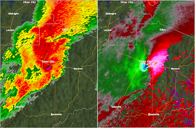
Radar image as the storm approached Dodge City posted by Bill Murray at Alabamawx.com.
Blog post by Dale Bader of WAAY 31.
Cullman Times article.
Cullman Times article. Note the comments about siren failure.
CBS 42 article and video.
WHNT 19 article.
2. Albertville - Gelraldine - Marshall/Dekalb counties - EF3 - 140 mph - 18.5 mile long path - 3/4 mile wide. In excess of 33 people were injured. Numerous buildings were damaged in Albertville, including the high school, large retail buildings, First Baptist Church, and numerous residences. Approximately 10:14 p.m.
NWS Huntsville storm survey including damage photos and radar images.
Blog post by Dan Satterfield of WHNT 19.
"Albertville Was Luckier Than Most" By Dan Satterfield of WHNT 19.
Radar image as the tornado was over Geraldine, posted by Bill Murray of Alabamawx.com.
Radar image after the storm passed Geraldine posted by Bill Murray at Alabamawx.com.
Video of damage at Albertville.
Damage pictures by Michelle Miklik on Alabamawx.com.
Scottsboro Daily Sentinal article.
Gadsden Times article.
Another Gadsden Times article.
WAAY 31 article, video.
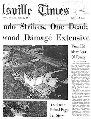
Huntsville Times article.
Photos from the Huntsville Times.
3. Mentone - Dekalb County - EF3 - 140 mph - 2.0 mile long path - 1/4 mile wide. Several mobile homes were completely destroyed southeast of Mentone. Several injuries were reported but no exact number has been determined as of this time. Approximately 11:15 p.m.
Survey by NWS Huntsville, including damage pictures and radar images.
Damage pictures from Alabamawx.com.
4. Mount Vernon (near Collinsville) - Dekalb County - EF4 - 170 mph - 7.3 mile long path, 1/4 to 1/2 mile wide. This storm impacted the Mount Vernon and Dog Town communities in extreme SE Dekalb. The McNutt Memorial United Methodist Church and a house next to it were completely destroyed. There was structural damage to residences along County Rd. 79 and mobile homes on County Rd. 60 were destroyed. Several injuries were reported but an exact number is unknown at this time. Approxinately 11:48 p.m.
NWS Huntsville storm survey, including radar images and damage pictures.
Pictures by Robyn Henry of the damage at Mount Vernon.
Radar image at the time of the warning, posted by Bill Murray on Alabamawx.com.
Mount Vernon damage pictures from Alabamawx.com.
From the NWS Birmingham:
5. Walker/Jefferson/Blount Counties - EF3 - 140 mph - 29.5 mile long path, 400 yards wide - 10:04 p.m. - 10:55 p.m. 70-80 homes and businesses were damaged and one was destroyed. No people were injured or killed as a result of the storm, but a 50 year old woman died on her way to a storm shelter when she slipped and fell.
Video of lightning associated with the tornadic storm.
Damage Photos from Cordova by Sandra Short.
Radar image I saved as tornado was near Sumiton.
Radar image as the tornado was near Cordova posted by Bill Murray on Alabamawx.com.
Radar image as the tornado was over Sumiton posted by Bill Murray on Alabamawx.com.
Radar image of the storm as it crossed I-65 posted by Bill Murray on Alabamawx.com.
6. Marion County - EF0 - 80 mph, 7.22 mile long path - 200 yards wide - 4:27-4:38 p.m. Three homes, a vehicle, and out buildings were damaged. 40-60 hardwood trees were uprooted. Tornado was on the ground from just SE of Gu-Win and travelled NE. There were no injuries or fatalities.
Tuscaloosa News article summarizing the tornadoes in Alabama.
7. Blount/Marshall Counties - EF1 - 100 mph - 2.18 mile long path - 200 yards wide - 9:59-10:09 p.m. A tornado formed 4 miles NE of Brooksville and moved NE. A few homes were damaged and a barn was destroyed. Several hundred trees were snapped and uprooted. There were no injuries or fatalities.
8. Fayette County - EF1 - 100 mph - 6.6 mile long path - 200 yards wide - 8:06-8:17 p.m. A tornado travelled from 2 miles south of the intersection of Highway 43 and County Road 26 to just south of Berry. Four homes received minor damage and several hundred trees were snapped or uprooted.
9. Fayette/Walker Counties - EF1 - 100 mph - 4.6 mile long path - 400 yards wide - 8:21-8:35 p.m. Tornado formed northeast of Berry in southeast Fayette and travelled into Walker, dissipating five miles west of Oakman. A 100 foot radio tower was blown down and several hundred tress were snapped or uprooted.
10. Hale County - EF0 - 80 mph - 5.84 mile long path - 100 yards wide - 11:50 a.m.-12:03 p.m. Tornado formed 5 miles northeast of Greensboro and travelled northeast, dissipating near Hogglesville. Three homes experienced minor damage and one barn was destroyed. 30-40 trees were uprooted.
...
A Few Sprinkles Tonight/Early Tomorrow - ON THE MAPS: An upper trough over the Southern Plains will bring clouds into Alabama today, and potential for a few sprinkles of rain tonight and early tom...
1 hour ago
